China’s Man-Made Islands in the Spratly’s and Why It’s Rising Concern Throughout the Region
Sümeyra Betül COŞKUN Bursa Uludağ University
The South China Sea is believed to be rich in oil and gas and is important for fishing reasons for the countries surrounding it. It is also crucial for its strategic location, as it is one of the world’s busiest waterways. For these reasons, it is subject to several overlapping territorial disputes which include China, Taiwan, Vietnam, Malaysia, Brunei and the Philippines. Among all these countries, China is seen as the most aggressive state among them. It is believed that China is aiming to create a strategic triangle within the South China Sea which could result in China gaining full control over the region. Such control is perceived as a direct threat for the US, most of the South China Sea states and US allies within the Asia-Pacific region. Therefore, China’s man-made islands located in the South China Sea, particularly in the Spratly archipelago, has raised attention both regionally and worldwide. At first, China started off with land reclamation in the area which started raising questions and caused tension on some level. These man-made islands are the result of China’s salami- slicing tactics at which it is very successful at. Then, China militarized its artificial islands and turned them into advanced military bases. As of today, China has 7 artificial islands located in the Spratly archipelago. When added to the islands in the area in which China has seized control over, it is possible to say that China has emerged as a serious strategic force in the region and is seen as a threat to mostly all whom directly have interest in the South China Sea.
KEY WORDS: China, South China Sea, Man-made Islands, Soil Reclamation, Spratly Islands
Introduction
The purpose of this study is to put forth a general introduction on China’a man-made islands in the Spratly’s and why these islands are raising concern both in the region and beyond the region. To better understand this topic, the importance of the South China Sea was touched upon first. In this part of the study, the importance of energy resources, fishing and shipping lanes in the South China Sea were briefly mentioned. After a brief introduction of the region, how China achieved building and militarizing these seven man-made islands in the Spratly’s are discussed followed by a general evaluation of these artificial islands according to international law. Lastly, why these islands are raising concern both in the region and beyond the region were touched upon.
The Importance of the South China Sea, Both On A Regional and Global Level
⦁ The South China Sea
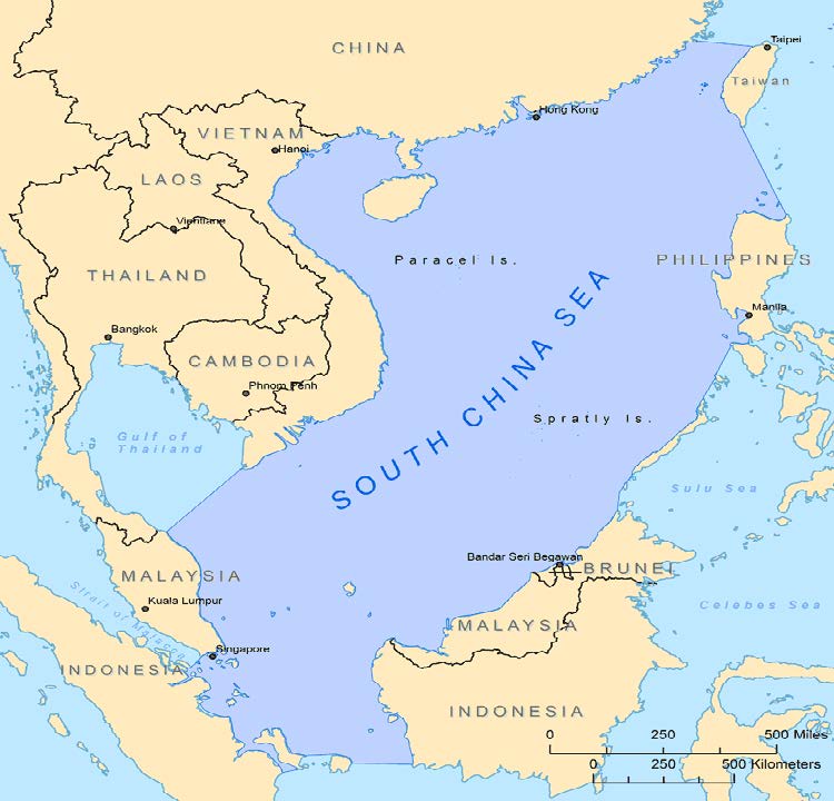
The South China Sea is the largest body of water after the five oceans. It is estimated to be around 3.700.000 square kilometers. It connects to the East China Sea with the Taiwan Strait and the Philippine Sea with the Luzon Strait. It also connects the Indian Ocean to the Pacific Ocean with the Strait of Malacca, which also is the regions most important waterway. The South China Sea is important for it’s energy resources, which consist of oil and gas, for fishing and for it’s shipping lanes. Generally speaking, it is important in terms of economic and strategic factors, which form the basis of the South China Sea conflicts.

Figure 1. The South China Sea
Energy Resources
The South China Sea is believed to contain important amounts of energy resources, although when the regions estimated energy reserves are taken into consideration, the region does not contain energy resources as much as other oil and natural gas-rich regions. Even so, it is still considered to be a crucial aspect for states within the region, hence is of great importance for the economies and policies of the states in the region. Therefore, energy resources are among the elements that form the basis of South China Sea conflicts. It is possible to say that these disagreements will become even
⦁ South China Sea.org, Hydrographic Boundaries of the South China Sea, http://www.southchinasea.org/files/2013/02/South-China-Sea-hydrographic-boundaries.png⦁ ,⦁ 27.07.2019.
more important as the energy consumption of developing Asian countries is expected to double by 2030, and half of this growth is expected to be generated by China alone.1
⦁ Oil
There is believed to be around 11 billion barrels of oil in the South China Sea, although this amount can vary from state to state. For example, according to the US, there are around 15.6 billion barrels of oil while according to China, there around 105- 213 billion barrels of oil.2 As one can see, the the amount increases massively, which is why the South China Sea is also sometimes referred to as “The Second Persian Gulf”. Chinese researchers hope to increase drilling investment interest in the region may be a possible explanation for the difference in claims. Another reason for the changing claims could be the media’s misunderstood interpretation of “resource estimates” (which predict the total amount of oil) and the “reserve estimates” (the generally recoverable amount, which is typically estimated at 10%).3 Lastly, the increasing tension between the South Sea states could be another reason researchers and potential oil drilling companies face, which may be a deterrent for investment.4 Thus, the question of how much oil is found in the South China Sea may continue to remain unanswered for the time being. If China’s estimates are correct, China and other South China Sea states energy demand from the Middle East and through the Strait of Malacca will be reduced.
⦁ Gas
Gas is another important energy resource in the region. In fact, according to estimations, the region is believed to be richer in gas reserves than oil reserves. It is believed that there is a total of 266 trillion cubic feet of natural gas in the open sea basins of the South China Sea.5 It is also estimated that natural gas consumption in the region will increase by 5% per year compared to other fuels and reach 20 trillion cubic feet per year in the next 20 years. 6 This makes gas reserves in the region even more crucial for region states. When we examine the chart below (Figure 2), we can see that the South China Sea is nearly 5 times richer in gas than the Gulf of Mexico and very close to the amount of gas reserves found in the North Sea Region. However,
1 Robert D. Kaplan, “Why the South China Sea is so crucial”, Business Insider Austrailia, 20.02.2015, , 30.05.2019.
2 Matthew R. Costlow, Gunboat Diplomacy in the South China Sea, (MSU Graduate Thesis), Springfield: Defense and Strategic Studies, 2012, p. 5.
3 Matthew R. Costlow, Gunboat Diplomacy in the South China Sea, (MSU Graduate Thesis), Springfield: Defense and Strategic Studies, 2012, p. 5.
4 Costlow, op.cit, pp. 5-6.
5 Tim Daiss, “South China Sea Energy Politics Heat Up”, Oil Price, 02.03.2019, , 30.05.2019.
6 Global Security, South China Sea Oil and Natural Gas, , 30.05.2019.
if we were to take a closer look, we see that the South China Sea’s gas production is half of what the Gulf of Mexico produces and a fourth of what is produces in the North Sea Region. This result shows the lack of infrastructure within the South China Sea region.
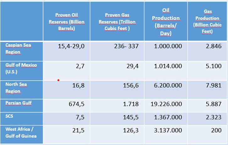
Figure 2. Comparison of Energy Reserves by Region
⦁ Fishing
Fishing is important both on a regional and global level for both economic and military reasons. Economically, about 50% of fishing ships in the world pass through the South China Sea which come to show how important just fishing is for the region.7 A large portion of the income of region states rely on fishing which has led to an overfishing problem. This is why in 1995, The United Nations (UN) formed the 1995 UN Fish Stocks Agreement. This agreement has opened the door to a number of regional fisheries management organizations (RFMOs) to cope with the excessive use of highly valuable but also highly mobile fish stocks that cross EEZ boundaries. This is the importance of fishing ecconomically. On the other hand, the importance of fishing militarily is due to Chinese fishermen carrying out paramilitary activities on behalf of
⦁ Ibid.
7 Gregory B. Poling, “Illuminating the South China Sea’s Dark Fishing Fleets”, Stephenson Ocean Security Project, 09.01.2019, fishing-fleets/, 31.05.2019.
their state; these fishermen are also referred to as “fishermen soldiers”.8 These fishermen soldiers have emerged as the largest power at sea (within the region), especially around the Spratly Islands. These fishermen carry the possibility of triggering at least as severe a conflict as the armed forces of China within the region; in fact, it is even more likely because a significant number of fishing boats in the region that are engaged in full-day handline fishing to function are a direct branch of the state through official marine militants.9 This is why these soldiers are a big threat to everyone who has interest in the region.
⦁ Shipping Lanes
According to the United Nations Conference on Trade and Development, 80% of global trade is carried out by the sea, and 60% of this trade passes through Asia; of this percentage (80%), the South China Sea carries out a third of global maritime trade, and China carries out 60% of its trade by sea.10 The Strait of Malacca, the Sunda Strait and the Lombok Strait are some of the important strait in the region. Of these straits, the Strait of Malacca is the most important. The reason this strait is the most important is because it provides the shortest, therefore, the most economical transition between the Pacific and Indian Ocean. To better comprehend the importance of this strait, a comparision with the Suez Canal and Panama Canal can be made. The Strait of Malacca carries out three times the amount of oil carried out by the Suez Canal and fifteen times more than the Panama Canal, and this is only an example of oil carried out through the strait.11 When the amount of other goods and energy resources that are carried out through the canal are taken into consideration, it is possible to say that the Strait of Malacca is not just important on a regional level, but also on a global level.
⦁ China’s Man-made Islands in the Spratly’s
⦁ China’s Salami-Slicing Tactics
Salami-slicing tactics, also known as the “cabbage strategy” in the military, was first used in the 1950’s by the Communist Party in Hungary. It was used as a strategy by the communist party for non-communist parties in Hungary. Today, China is amoung, if not the most, the most successful user of this strategy. China is the only state that
8 Andrew S. Erickson and Conor M. Kennedy, “China’s Maritime Militia”, CNA, S. 7, , 22.06.2019.
9 Yamaguchi, “Strategies of China’s Maritime Actors in the South China Sea: A Coordinated Plan under the Leadership of Xi Jinping?”, p. 24.
10 China Power, How much trade transits the South China Sea?, transits-south-china-sea/, 31.05.2019.
11 Robert D. Kaplan, “Why the South China Sea is so crucial”, Business Insider Austrailia, 20.02.2015, , 30.05.2019.
has expanded its borders in the region after World War II, both on land and at sea, despite of its neighbors.12 China has used these tactics in 1974, when it occupied the Paracel Islands, right after the US withdrew from Vietnam. It also used the same tactics on the Spratly’s in 1988. During that time, both the US and the Soviet Union had other things on their agenda. China used this towards its own benefit and occupied some land in the Spratly archipelago. Another example that could be given is when China occupied Mischief Reef in 1995; however, this time China actually attracted unwanted attention from the US. This unwanted attention led to the first US South China Sea policy, however, this attraction is not significat at all when compared to the 2011 US South China Sea (Rebalance) policy.
China not only uses this strategy in the South China Sea but also the East China Sea, Taiwan and the border of India. So how does China use this strategy? First of all, it starts off by claiming rights over a region and repeats its claim on the region on all the possible platforms. Subsequently, it propagates in response to the claim of the other party, this way the region in question is considered to carry a dispute between China and the other party; at this point, China then uses its military and diplomatic power to resolve the conflict.13 This way China can constantly repeat and increase the power of its actions and have a permanent presence in the claimed region.
⦁ China’s Man-made Islands in the Spratly’s
Although China first occupied the majority of its seven reefs in 1988, it first started building its man-made islands in the Spratly’s in December of 2013. China drained sand from the bottom of the ocean and piled the drained sand on top of the reef, hence forming an artificial island. China continued its soil reclamation activities in 2014. Towards the end of 2014 and in 2015, it started militarizing the islands. The main reason China started militarizing the islands were due to the US control of international trade in the Indian and Pacific Ocean. As of today, there are seven artificial islands in the Spratly archipelago; Subi Reef, Fiery Cross Reef, Mischief Reef, Gaven Reef, Johnson South Reef, Hughes Reef and Cuarteron Reef (see Figure 3). China built short-range air defense systems with large anti-aircraft guns on each of these islands. The distance of these reefs/man-made islands to mainland China is more than 800 km. It is estimated that 11 billion barrels of oil and 190 cubic meters of gas are in the waters surrounding these artificial islands.14 Subi Reef, Fiery Cross
12 Prabhash K Dutta, “What is China’s salami slicing tactic that Army chief Bipin Rawat talked about?”, India Today, 07.09.2017, general-bipin-rawat-1039864-2017-09-07, 25.06.2019.
13 Prabhash K Dutta, “What is China’s salami slicing tactic that Army chief Bipin Rawat talked about?”, India Today, 07.09.2017, general-bipin-rawat-1039864-2017-09-07, 25.06.2019.
14 David Brennan, “U.S. Could ‘Take Down’ Man-Made Islands In South China Sea If It Needed To Says Pentagon Official”, Newsweek, 06.01.2018, islands-south-china-sea-if-it-needed-says-pentagon-952451, 24.05.2019.
Reef and Mischief Reef are amoung the biggest and most equipped of these seven artificial islands. These three islands also form a triangle. Subi Reef is located in the North part of the Spratly archipelago, while Fiery Cross Reef is located in the southwest and Mischief Reef is located in the southeast of the archipelago. Together, it can be said that they form a strategic triangle in the Spratly archipelago. Gaven Reef is located in the center of this triangle while both Johsnon South and Hughes Reef are located amoung the south border of the triangle. Cuarteron Reef is located to the southwest, outside of the triangle but holds great importance strategically.
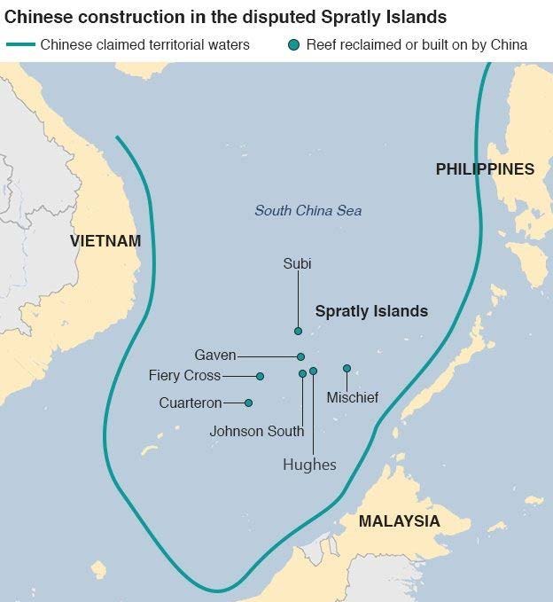
Figure 3. China’s Artificial Islands in the Spratly Archipelago
Subi Reef is one of the three big and advanced artificial reefs in the are. It is located on the North part of the Spratly archipelago and is 25 nautical miles (nm) from the
⦁ BBC News, China media denounce US warship in South China Sea, 28.10.2015, ⦁ https://www.bbc.com/new⦁ s/world-asia⦁ -china-34655845, 24.05.2019.
Philippines.15 It is a low-tide island that is normally under sea level. It is claimed by China, Taiwan, Philippines and Vietnam. It was first occupied by China in 1988. Later, in 1990, China started construction on the island. In 2014, China started soil reclamation. As of today, the island is home to an access channel, eleven temporary loading piers, a 3000 meter airfield, a large facility, seven possible satellite communication antennas, a possible security watchtower with a radome, reinforced sea walls, a helipad, a pre-existing military facility and three power plants.16
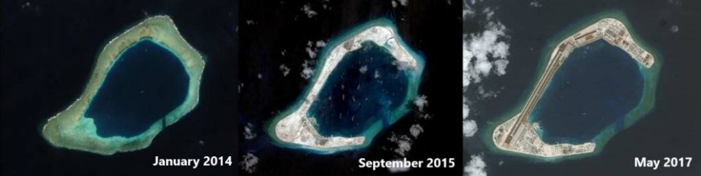
Figure 4. Subi Reef
Fiery Cross Reef is the second of the three advanced artificial islands. It is located on the West part of the Spratly archipelago. It happens to be the most advanced artificial reef in the area. It is estimated to be around 2.740.000 m² and is claimed by China, Taiwan and Vietnam. China started the islands soil reclamation in 2014. The same year, it started the construction of an airfield and completed it by 2015. To better protect the navigation and transportation security in the South China Sea, China also announced it had established a South China Sea Rescue Center in 2019.17 Currently on the reef there is an airfield, a port (630,000 square meters) large enough to accommodate tankers and large surface fighters, multiple cement plants, multiple support buildings, nine temporary loading piers and a pre-existing pier, pre-existing air defense weapons, a possible radar tower under construction, eight possible weapon sites, anti-frogman defense systems, communication equipment, a greenhouse, two heliports, a military facility, a new multi-storey administrative facility adjacent to the airstrip, two lighthouses and ten possible satellite communication antennas.18
15 The Strait Times, Before and after satellite images: What has been built on the reefs that China occupies in the Spratlys, 29.02.2016, images-what-has-been-built-on-disputed-islands-in-the-south, 25.05.2019.
16 Southfront, Island Building in South China Sea, china-sea-review/, 25.05.2019.
⦁ Subi Reef, ASIA MARITIME TRANSPARENCY INITIATIVE, , 05.25.2019.
17 MAREX, “China Establishes South China Sea Rescue Center”, The Maritime Executive, 29.01.2019, , 25.05.2019.
18 Southfront, ibid.
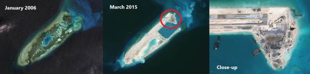
Figure 5. Fiery Cross Reef
Mischief Reef is the last of the three advanced artificial islands that form the triangle and is 129 nm from the Philippines. It is claimed by China, Taiwan, the Philippines and Vietnam. It was first occupied by China in 1995, as mentioned before, when it’s salami tactics first attracted unwanted international attention. It is located on the east of the Spratly archipelago. China started soil reclamation on the island in 2015. The island is around 5.580.000 m² and is believed that China is expanding the entrance of the reef to build an naval air station on top of it.19 There is currently an access channel, a fortified sea wall, nine temporary loading docks, nine cement plants, two pre- existing military facilities, a pre-existing shelter for fishermen, and three possible satellite communications antennas on the Mischief Reef.20 Frigate and coast guard ships have also been identified in the surrounding waters, and a huge array of antennas have been established, which is thought to enhance China’s ability to monitor the environment.21
⦁ BBC News, Flying close to Beijing’s new South China Sea islands, 14.12.2015, ⦁ https://www.bbc.com/news/⦁ magazine-35031313⦁ , 24.05.2019; New York Times, What China has been building in the South China Sea, 27.10.2015, ⦁ https://www.nytimes.co⦁ m/interactive/2015/07/30/world/asia/what-china-has-been-building-in-the-south- china-sea.html,10.05.2018.
19 Southfront, ibid.
20 Southfront, ibid.
21 CNBC, China builds new military facilities on South China Sea islands: think tank, 30.06.2017, , 24.05.2019.
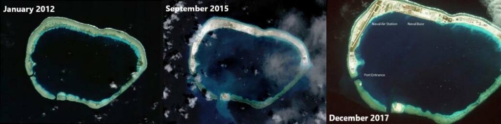
Figure 6. Mischief Reef
Cuarteron Reef is located to the southeast of the “triangle” in the Spratly archipelago. It is claimed by China, Taiwan, the Philippines and Vietnam. It was occupied by China in 1988, construction on the island started in 1990 and soil reclamation started in 2014. Although Cuarteron Reef is located outside of the triangle, it is believed to be strategically important. Experts believe that Cuarteron Reef improves China’s abitility to monitor air and sea traffic in the South China Sea, especially in the Strait of Malacca. Therefore, Cuarteron Reef is considered to be strategically significant for the South China Sea. Currently, the reef is equipped with a 125-meter wide access channel, breakwaters, multiple support buildings, three power stations, two heliports and reinforced sea walls.22 Although it is not certain, it is assumed that there are five possible communication antennas, a radar facility, two radar towers under construction, missile sites, a pre-existing large multi-level military facility and a satellite communication antenna.23 It is also thought to contain some kind of short- range ship air defense system with an anti-aircraft.24
⦁ BBC News, https⦁ ://www.bbc.com⦁ /news/⦁ magazine-35031313 and Daniel Bishton, Mischief-Reef- Analysis-1, Spatial Source, 06.03.2018, ⦁ https://www.spatialsource.com.⦁ au/gis-data/satellite-images- reveal-completed-military-bases-spratly-islands/attachment/mischief-reef-analysis-1. 25.05.2019.
22 Southfront, ibid.
23 Amanda Macias, “This satellite image of Chinese construction in South China Sea is a wake-up call to us all”, Business Insider, 14.07.2016, 2016-7, 24.05.2019.
24 AMTI, China’s New Spratly Island Defenses, 13.12.2016, island-defenses/, 25.05.2019.
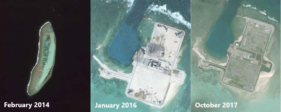
Figure 7. Cuateron Reef
Gaven Reef is located in the middle of the “triangle”. It is claimed by China, Taiwan, the Philippines and Vietnam. It is located on the Tizard Banks. It was occupied by China in 1988. There used to just be an old and small facility on the reef but after China’s soil reclamation on the island, it built an artifical island on the bank and connected it with the small facility (see Figure 8.). The reef is believed to contain an anti-aircraft defense system and other small objects; although the objects cannot be identified, they are thought to be a kind of short-range ship air defense system that provides protection against cruise missile attacks.25
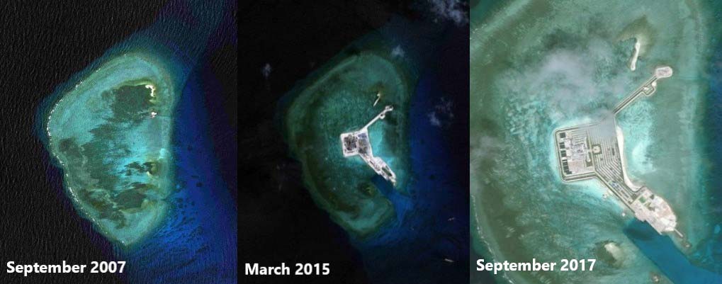
Figure 8. Gaven Reef
Johnson South Reef is the sixth reef and is located along the south line of the “triangle”. It is located on Union Bank and is claimed by China, Taiwan, the Philippines and Vietnam. It was occupied by China in 1988 after a battle with Vietnam. On the reef there is a 125 meter wide access channel, a concrete plant, defense towers, desalination pumps, a fuel tank, a multi-level military facility, a possible radar facility, a small port and two loading stations, a 3,000 m² port area, four possible gun towers, a lighthouse and a possible solar power farm that contains 44 panels, a pre-existing communication facility, a pre-existing garrison building, two heliports, Ro-ro (roll on, roll off) ports, a large pre-existing military multi-level military facility, a pre-existing pier, reinforced sea walls, three possible satellite
⦁ ASIA MARITIME TRANSPARENCY INITIATIVE, Cuarteron Reef, reef/, 05.25.2019.
25 AMTI, ibid.
⦁ Asia Maritime Transparency Initiative, Gaven Reefs, , 24.05.2019.
communication antennas, two possible radar towers under construction and two wind turbines.26
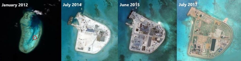
Figure 9. Johnson South Reef. The red area indicated in the first photo is the area focused on in the subsequent photos.
The last of the seven reefs is Hughes Reef. Hughes Reef is also located on Union Bank and is to the east of Johnson South Reef. Like Johnson South Reef, it is claimed by China, Taiwan, the Philippines and Vietnam but unlike Johnson South, it is also claimed by Malaysia. It is normally a low-tide reef and is around 76.000 m². It was occupied by China in 1988 and soil reclamation started in 2014. On the reef there is an access channel, coastal walls, four defense towers, a port of 292,000 m², a 35,350 m² pier, a multi-level military facility, a possible radar facility, a pre-existing helicopter runway, a pre-existing lighthouse, reinforced sea walls and a cement factory.27
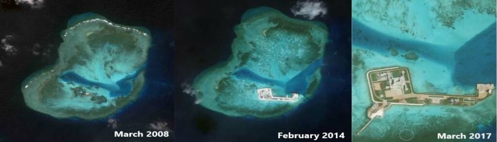
Figure 10. Hughes Reef
26 Southfront, ibid.
⦁ Asia Maritime Transparency Initiative, Johnson Reef, , 05.25.2019.
27 Southfront, ibid.
⦁ Asia Maritime Transparency Initiative, Hughes Reef, , 05.26.2019.
⦁ The Evaluation of China’s Artificial Islands in terms of International Law
If we were to evaluate China’s man-made islands according to international law, in this case The United Nations Convention on the Law of the Sea (UNCLOS), we can see that these artificial islands are not considered as islands and cannot benefit from an islands legal status. Article 121. Regime of Islands, subparagraph 1 of UNCLOS states that an island is a naturally formed area of land, surrounded by water, which is above water at high-tide.28 China’s artificial islands are not naturally formed and is not above water at high-tide. Before moving on to the second subparagraph of this article, it is better to move on to subparagraph three to better comprehend subparagraph two of Article 121. Subparagraph three of Regime of Islands state that rocks that cannot sustain human habitation or economic life of their own should not have an exclusive economic zone or continental shelf.29 From this subparagraph we understand that an island needs to sustain human habitation or have an economic life of their own. Since the word ‘or’ here instead of ‘and’, it indicates that one is enough for a piece of land to be considered as an island. Although China’s man-made islands do not sustain human habitation or economic life on their own, therefore they do not have the right to an exclusive economic zone or continental shelf. The second subparagraph of Articile 121 states that “Except as provided for in paragraph 3, the territorial sea, the contiguous zone, the exclusive economic zone and the continental shelf of an island are determined in accordance with the provisions of this Convention applicable to other land territory”.30 The notions of exclusive economic zone and continental shelf are important here. From this, we can understand that an island has the same marine jurisdictions as any land area, including 12 nm of territorial waters, 200 nm of EEZ and a continental shelf that can exceed 200 nm.31 On the other hand, while it states that states dominating the islands may declare EEZ around the island, artificial islands do not have any rights to maritimes zones besides the 500 meters of security.32
⦁ Why China’s Man-made Islands are Raising Concern
⦁ Conflicts within the Region with South China Sea States
As we mentioned before, the South China Sea is important for its energy resources, fishing and shipping lanes. These are all factors that are both economically and
28 United Nations Convention on the Law of the Sea, PART VIII. REGIME OF ISLANDS, Article 121 (1), p. 66.
29 Ibid., Art. 121 (3).
30 Ibid., Art. 121 (2).
31 Robert C. Beckman, et.al., Beyond Territorial Disputes in the South China Sea: Legal Frameworks for the Joint Developement of Hydrocarbon Resources, Massachusetts: Edward Elgar Publishing, 2013, p. 55.
32 Cemre Pekcan, “Uluslararası Hukuk Çerçevesinde GÇD Krizinin Değerlendirilmesi”, ANKASAM, Vol. 1 (3) , December 2017, p. 59.
strategically important for South China Sea states, hence they form the basis of the South China Sea territorial conflicts. The five big islands that are located in the South China Sea and are subject to these conflicts are the Paracel Islands, Spratly Islands, Scarborough Shoal, Pratas Island and Macclesfield Bank. China claims sovereignity on all of these islands and the waters surrounding them. In fact China claims to have rights on almost all of the South China Sea with it’s “nine-dash line” policy (see Figure 11). Taiwan’s claims in the South China Sea are exactly the same as China’s claims, as it’s claims are based on the same elements as China’s claims. Vietnam also claims to have rights on all islands, but unlike China and Taiwan, it doesn’t claim any rightson Pratas Island. The Philippines and Malaysia claim rights on only some features located in the South China Sea. Currently, Brunei doesn’t claim any of the features except for Louisa Reef located in the Spratly archipelago which actually falls within it’s exclusive economic zone (EEZ). The South China Sea conflicts are and have been a hot topic for awhile within the region between region states, and because China’s man-made islands are located in such a strategic point that gives China the upperhand, China’s man-made islands raise a big concern for region states.
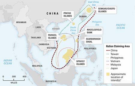
Figure 11. Controversial islands in the South China Sea
If we were to look at these claims accordingly with international law, we can see that the Spratly archipelago only falls within the EEZ zone of the Philippines, Malaysia and Vietnam (see Figure 12). Some of the islands in the Spratly archipelago actually isn’t located in any states EEZ zone and falls under international waters. China on the
⦁ Some changes were made on map, for original map, see: Craig HILL, “America warns China about South China Sea claims”, China Daily Mail, 03.06.2017, warns-china-about-south-china-sea-claims/, 03.03.2018.
other hand claims to have rights on all of the Spratly archipelago and most of the South China Sea based on it’s “nine-dash line” policy. Some of the South China Sea states openly objected to China’s historical claims and nine-dash line policy and brought this subject to the UN Arbitration Court. On July 1 of 2016, The Permanent Court of Arbitration at the Hague came to decision that China’s nine-dash line policy, which China used to determine the boundaries of China’s claims in the South China Sea, were not based on a legal basis and China’s actions are contrary to international law.33 However, China rejected the court’s decision and although China is a party to UNCLOS, it had refused to participate in arbitration from the beginning, so the court’s decision does not directly have any binding on China.34
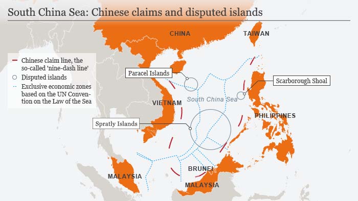
Figure 12. EEZ zones in the South China Sea and China’s Nine-Dash Line Policy
33 Euan Graham, “The Hague Tribunal’s South China Sea Ruling: Empty Provocation or Slow-Burning Influence?”, Council on Foreign Affairs, 18.08.2016, , 23.05.2019.
34 Ibid.
⦁ DW, China keeps building infrastructure on disputed islands in South China Sea, 15.12.2017, ⦁ https://www.dw.com/e⦁ n/china-keeps-⦁ building-infras⦁ tructure-on-disputed-islands-in-south-china-sea/a- 41805980, 17.05.2018.
⦁ China’s Man-made Islands on a Global Level
⦁ China’s ‘Strategic Triangle’ in the South China Sea
The Spratly archipelago consists of 12 island groups with a total of over 100 islands. Half of these islands have been occupied by China, Taiwan, the Philippines, Malaysia and Vietnam.35 As we mentioned above, China has seven man-made islands in the Spratly archipelago and these seven man-made islands are all located in a way that benefits China. China has also occupied the Paracel Islands and has established 20 advanced outpost on the islands. The biggest island in the Paracel Islands is Woody Island, which China first occupied in 1955. China started soil reclamation activities on the island in 2014 and started militarizing the island in 2015; that being said, China’s military activities on the Paracel Islands are no where near as advanced as it’s military activities in the Spratly Islands. China also has a general control over the Scarborough Shoal. Scarborough Shoal is a high-tide reef claimed by China, Taiwan and the Philippines. There are no building built on the reef, but China, which has consistently maintained a coast guard around the reef since 2012, effectively controls the reef.36 The biggest concern here for global dominant states and region states, is the fear of the South China Sea becoming a huge “Chinese Lake”.37 If China were to militarize all three of these island groups, the Spratly’s, Paracels and Scarborough Shoal, then it could form a “strategic triangle” in the South China Sea (see Figure 13). In this case, China would have the ability to control the region under an air defense identity that would cover most of the South China Sea, effectively transforming the sea into a “Chinese lake”, which would pose a serious threat to all region states and global dominant powers such as the US.
35 CIA, The World Factbook, Spratly Islands, world-factbook/geos/pg.html, 03.03.2018.
36 AMTI, Scarborough Shoal, , 02.06.2019.
37 Jesse Johnson, “China planning ‘monitoring station’ on hotly contested South China Sea shoal”, The Japan Times, 17.03.2017, monitoring-station-hotly-contested-south-china-sea-shoal/#.XPfrf4gzY2w, 02.06.2019.
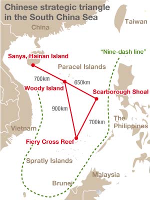
Figure 13. The Strategic Triangle in the South China Sea
⦁ The Strait of Malacca
Another important matter globally is the Strait of Malacca. It is believed that China is building a new strategic maritime route by building artificial islands in the Spratly archipelago and installing land-to-air missiles on the Paracel Islands. The importance of the Strait of Malacca globally for both economic and strategic matters was mentioned earlier. After passing the Strait of Malacca, ships would have to pass by Spratly Archipelago and the Paracel Islands in order to pass through the South China Sea. Therefore, the dominant power or state controlling this region would be the dominant power of the South China Sea in general. The dominant power of the South China Sea would also be considered a global power at seas, as a third of the world’s
⦁ Kōda Yōji, Confronting China’s Island-Building Campaign, Nippon, 15.09.2015, ⦁ https://www.nippon.com/⦁ en/currents/⦁ d00190/confronting-china%E2%80%99s-island-building- campaign.html, 10.30.2019.
maritime trade passes through it. This is why China’s man-made islands in the Spratly’s, especially Cuarteron Reef for this matter, is important for the future of the Strait of Malacca.
⦁ China’s Progress in the Region
Last of all, China’s man-made islands raise a global concern for the island chains in the Asia-Pacific. China currently has a general control over the Spratly archipelago and the Scarborough Shoal which are along the south part of the First Island Chain. If China were to have control over Taiwan too, it would be the dominant power within the First Island Chain (see Figure 14). This is something the US and Japan especially want to prevent because then China would move on to the Second Island Chain. This is why both countries are closely involved with China’s actions towards Taiwan.
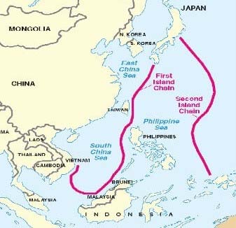
Figure 14. The Island Chains in the Asia-Pacific
⦁ Right Side News, The United States Should Lead with Power and Purpose on China, 29.12.2013, ⦁ https://www.rightsidenews.com/us/hom⦁ eland-security/the-united-states-should-lead-with-power-and- purpose-on-china/, 25.06.2019.
Conclusion
China’s man-made islands are a concern both regionally, for South China Sea states, and globally, for dominant powers at sea. These artificial islands are a result of China’s successful salami-slicing tactics. The artificial islands are strategically located in an area which gives China a great advantage for both economical and strategical reasons and complete China’s wish to gain control over the South China Sea, which it sees as it’s own ‘backyard’. These islands give China the mobility it desires in the Spratly archipelago. Combined with other islands China has control over, they form the South China Sea into what can be referred to as a “Chinese Lake”. Because of this control, China is currently the dominant power in the South China Sea and it’s man-made islands are one of the main reasons China is where it is.
REFERENCES
AMTI, China’s New Spratly Island Defenses, 13.12.2016, , 25.05.2019.
AMTI, Scarborough Shoal, , 02.06.2019.
ASIA MARITIME TRANSPARENCY INITIATIVE, Cuarteron Reef,
, 05.25.2019.
Asia Maritime Transparency Initiative, Gaven Reefs, reefs/, 24.05.2019.
Asia Maritime Transparency Initiative, Hughes Reef, reef/, 05.26.2019.
Asia Maritime Transparency Initiative, Johnson Reef, reef/, 05.25.2019.
BECKMAN Robert C., et.al., Beyond Territorial Disputes in the South China Sea: Legal Frameworks for the Joint Developement of Hydrocarbon Resources, Massachusetts: Edward Elgar Publishing, 2013.
BBC News, China media denounce US warship in South China Sea, 28.10.2015, , 24.05.2019.
BBC News, Flying close to Beijing’s new South China Sea islands, 14.12.2015, , 24.05.2019.
BBC News, , 25.05.2019.
BISHTON Daniel, Mischief-Reef-Analysis-1, Spatial Source, 06.03.2018, military-bases-spratly-islands/attachment/mischief-reef-analysis-1, 25.05.2019
BRENNAN David, “U.S. Could ‘Take Down’ Man-Made Islands In South China Sea If It Needed To Says Pentagon Official”, Newsweek, 06.01.2018, sea-if-it-needed-says-pentagon-952451, 24.05.2019.
China Power, How much trade transits the South China Sea?, , 31.05.2019.
CIA, The World Factbook, Spratly Islands, , 03.03.2018.
CNBC, China builds new military facilities on South China Sea islands: think tank,
30.06.2017,
south-china-sea-islands.html, 24.05.2019.
COSTLOW Matthew R. Costlow, Gunboat Diplomacy in the South China Sea, (MSU Graduate Thesis), Springfield: Defense and Strategic Studies, 2012.
DAISS Tim Daiss, “South China Sea Energy Politics Heat Up”, Oil Price, 02.03.2019,
Heat-Up.html, 30.05.2019.
DUTTA Prabhash K., “What is China’s salami slicing tactic that Army chief Bipin Rawat talked about?”, India Today, 07.09.2017, general-bipin-rawat-1039864-2017-09-07, 25.06.2019.
DW, China keeps building infrastructure on disputed islands in South China Sea, 15.12.2017,
disputed-islands-in-south-china-sea/a-41805980, 17.05.2018.
ERICKSON Andrew S. & KENNEDY Conor M., “China’s Maritime Militia”, CNA, , 22.06.2019.
Global Security, South China Sea Oil and Natural Gas, , 30.05.2019.
GRAHAM Euan, “The Hague Tribunal’s South China Sea Ruling: Empty Provocation or Slow-Burning Influence?”, Council on Foreign Affairs, 18.08.2016, , 23.05.2019.
HILL Craig, “America warns China about South China Sea claims”, China Daily Mail, 03.06.2017,
about-south-china-sea-claims/, 03.03.2018.
JOHNSON Jesse, “China planning ‘monitoring station’ on hotly contested South China Sea shoal”, The Japan Times, 17.03.2017, monitoring-station-hotly-contested-south-china-sea-shoal/#.XPfrf4gzY2w, 02.06.2019.
KAPLAN Robert D., “Why the South China Sea is so crucial”, Business Insider Austrailia, 20.02.2015,
sea-is-so-crucial-2015-2, 30.05.2019.
MACIAS Amanda, “This satellite image of Chinese construction in South China Sea is a wake-up call to us all”, Business Insider, 14.07.2016, , 24.05.2019.
MAREX, “China Establishes South China Sea Rescue Center”, The Maritime Executive, 29.01.2019,
establishes-south-china-sea-rescue-center, 25.05.2019.
New York Times, What China has been building in the South China Sea, 27.10.2015, china-has-been-building-in-the-south-china-sea.html,10.05.2018.
PEKCAN Cemre, “Uluslararası Hukuk Çerçevesinde GÇD Krizinin Değerlendirilmesi”, ANKASAM, Vol. 1 (3) , December 2017.
POLING Gregory B., “Illuminating the South China Sea’s Dark Fishing Fleets”, Stephenson Ocean Security Project, 09.01.2019, fleets/, 31.05.2019.
Right Side News, The United States Should Lead with Power and Purpose on China, 29.12.2013,
united-states-should-lead-with-power-and-purpose-on-china/, 25.06.2019.
South China Sea.org, Hydrographic Boundaries of the South China Sea, boundaries.png, 27.07.2019.
Southfront, Island Building in South China Sea, artificial-islands-south-china-sea-review/, 25.05.2019.
Subi Reef, ASIA MARITIME TRANSPARENCY INITIATIVE,
, 05.25.2019.
The Strait Times, Before and after satellite images: What has been built on the reefs that China occupies in the Spratlys, 29.02.2016, has-been-built-on-disputed-islands-in-the-south, 25.05.2019.
United Nations Convention on the Law of the Sea, PART VIII. REGIME OF ISLANDS, Article 121.
YAMAGUCHI, Shinji, “Strategies of China’s Maritime Actors in the South China Sea: A Coordinated Plan under the Leadership of Xi Jinping?” China Perspectives. 2016.
YOJI Kōda, Confronting China’s Island-Building Campaign, Nippon, 15.09.2015, island-building-campaign.html, 10.30.2019.
Leave a Reply